![]()

Walking in Canary Islands & Madeira - Guide Books & Maps
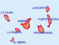
The Canary Islands are situated off the west coast of Africa but as Spanish colonies enjoy infrastructure to European standards. The climate is heavily influenced by their situation in the NE trade winds which often cause a bank of windward cloud between 1500 and 1800 metres below an inversion. Fuerteventura and Lanzarote however, being nearer the African coast and lower in altitude are generally less effected and may experience a hot dry "Leste" wind blowing off the coast of Africa. Fuerteventura is virtually a desert and hardly ever enjoys rain It also has strong winds and has been described as North Africa without the snakes.
Walking in the Canary Islands (west) Dillon Cicerone
Walking in the Canary Islands (east) Dillon Cicerone
Eyewitness general tourist guide
Getting
about in the Canaries
The
islands are connected by car ferries and aircraft. Most scheduled British
direct flights go to Tenerife South (Reina Sofia) airport, charters go
direct to some other islands. Check British Midland, BA and Monarch for
scheduled flights to Tenerife. Most inter island flights connect with Tenerife
North. Most Spanish airlines connect UK and the Canaries via Madrid. Ferry
companies are Fred Olsen <website>,
Trasmediterranea
<website>
and Armas <website>. Inter
island flights are by Binter's <website>
fleet of medium sized planes.
Car
hire companies generally do not allow cars to be moved between islands.
Cicar <website>is the main Canary
Island Car hire company. Autos Bamir <website>
on El Hierro.
If
stopping over in Tenerife, the charming capital Santa Cruz is near the
north airport (Los Rodeos) and Hotel Mencey<email>![]() is excellent if quite expensive. The other major town of the Canaries is
Las Palmas on Gran Canaria. Hotel Santa Catalina
is centrally situated.
is excellent if quite expensive. The other major town of the Canaries is
Las Palmas on Gran Canaria. Hotel Santa Catalina
is centrally situated.
Each
island has a Parador except Gran Canaria (proposed to open 2007), Lanzarote
and Fuerteventura (sold off).
Fuerteventura
I cannot fully recommend Fuerte' as a walking destination. It has lots of mountains, with a fine range in the far south and dune systems, (most of the island is desert or lava). However I find it a bit too dry, dusty, hot and windy for walking ("Fuerteventura" either means strong fortune or strong wind, on one day in 1999 in Jandia I experienced wind blowing down off the mountains to "knock down" force at sea level). I have been there many times to explore the jeep tracks by 4x41, looking for deserted beaches I have hardly ever seen anybody doing a serious walk in summer, perhaps winter would be best, windsurfing is a very popular activity on the island.
1] Don't drive on the beaches, which incidentally are all naturist away from the resorts.
Jandia & Herr Winter
Accounts are varied, but it seems that the extreme south of Fuerte' was connected with the mysterious Herr Winter from some time in the 1930s . His deserted house is easy to spot from Barlavento beach and it is possible to trace the remains of the airstrip he built near the lighthouse. The large Villa Winter was bulit at the end of WW2. Why a German might need an isolated house and an airstrip half way between Europe and South America in 1945 has resulted in some speculation. The family are said to have claimed it was an agricultural project, which seems improbable.
You
can check the accuracy of tourist maps by seeing how they treat Cofete.
I know one that ignores the huge Moro Jable tourist development and shows
Cofete as having a main road to it, also showing the airstrip remains as
an airport!
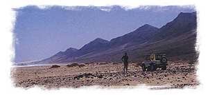 Most
of the tourist accommodation is in big purpose built resorts dotted down
the east coast by major beaches. Also at rapidly growing Corralejo in the
far north (many English people here). The west coast is almost deserted
with just a few small fishing villages, and the far south west (Cofete)
can only be reached by an unsurfaced mountain pass (4x4
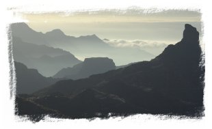
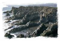
best). Cofete looks down on to Barlavento, a largely deserted beach backed
by mountains, (unsafe for swimming).(photo, right)
Most
of the tourist accommodation is in big purpose built resorts dotted down
the east coast by major beaches. Also at rapidly growing Corralejo in the
far north (many English people here). The west coast is almost deserted
with just a few small fishing villages, and the far south west (Cofete)
can only be reached by an unsurfaced mountain pass (4x4
best). Cofete looks down on to Barlavento, a largely deserted beach backed
by mountains, (unsafe for swimming).(photo, right)
The
capital is the headquarters of the Spanish Foreign Legion, and has little
to offer the visitor. If I haven't put you off yet you must be made of
Fuerte - stuff so get a copy of Landscapes of Fuerteventura.![]() See
you there!
See
you there!
AA
Island map Fuerteventura![]()
 Photos
with notes on Gran Canaria walks, resorts, mountains and hotels
Photos
with notes on Gran Canaria walks, resorts, mountains and hotels
Volcanic island typical of the Canaries. Mountain ridges rise from the sea to the high central point at Pico de las Nieves 1949m (5941ft) 50 summits of 1000m.
Mountain Walks
in Gran Canaria García![]() 20
selected graded mountain walks (700-1100 metres of ascent each) from his
Spanish volume of 50 walks translated into English, nice colour route sketch
maps, no photographs or general maps (designed to be used with a map).
13x2070p colour sketch maps unillustrated.
20
selected graded mountain walks (700-1100 metres of ascent each) from his
Spanish volume of 50 walks translated into English, nice colour route sketch
maps, no photographs or general maps (designed to be used with a map).
13x2070p colour sketch maps unillustrated.
Discovery Walking
guides:
South and mountains![]()
Gran Canaria
Mountains, tour and trail map 1:40000 +35 walks with
GPS waypoints![]()
Plant and Flower
guide
Booklet
form in plastic wallet, cultivated and wild plants with photo and description![]()
Landscapes of
Gran Canaria Rochford![]()
![]() 20
walks less focused on the mountains than the Garcia book. Illustrated.
20
walks less focused on the mountains than the Garcia book. Illustrated.
AA Island map
Gran Canaria![]()
La Gomera's highest mountains are rounded hills covered in laurel forest watered by the clouds of the NE trade winds. On a day when the summit of Guarajonay (1487m) is just above the clouds they make atmospheric walking through forest tracks of misty sunbeams. Climbing Guarajoney from the nearest road can be enlivened by extending the walk to the "Bar Sonia" in Chipude for lunch. Or for a more interesting mountain try Forteleza 1243m. just to the west. A drive from the capital San Sebastian to Valle Gran Rey will give views of all the dramatic summits of the island.
San Sebastian, largely unspoilt by tourism, pleasant capital with ferry terminal and beach.
Playa de Santiago, fairly pleasant resort with beaches to east of town and with terrifying small airstrip.
Vueltas, La Playa - Valle Gran Rey, two resorts occupied by German package tourists, some pretending to be hippies, and dropouts along with a quasi religious meditation centre ("Keep out" signs in German) in place of beach bar. Avoid.
Discovery Walking
Guides:
Tour and Trail
map La Gomera 1:40000 (with GPS waypoints) (Super durable)![]()
Walk! La Gomera
35
walks in the usual Discovery format, with extract map sections and small
photos adorning the route descriptions. I would echo the authors comment
that some of the Gomera ascents can be disappointing to those wishing for
a sense of escape from the realms of man as some of the higher summits
have, of necessity on this corrugated island, roads over them.
Walks
in four sections corresponding to the compass points, including Valle Gran
Rey in the west, Garajoney in the north and barrancos everywhere.
![]()
Drive! La Gomera
touring
map, I wouldn't tour without a Discovery map if one is available ![]()
Plant and flower
guide
Booklet
form in plastic wallet, cultivated and wild plants with photo and description![]()
Landscapes of
Southern Tenerife and Gomera![]()
AA Island map
La Gomera![]()
Can
be combined with Tenerife
Photos of La Palma walks and drives
 La
Palma is one of the better choices for a walking holiday in the Canaries.
It's volcanic mountains form the shape of a frying pan with the south oriented
"handle" formed by the ridges of the Cumbre Vieja and the Cumbre Nueva
and the pan by the huge collapsed crater of the Caldera de Taburiente.
The principal walks, for fit, surefooted walkers with a head for heights,
take in these summit ridges. As mountain roads and forest tracks also access
the ridges at several points and provide opportunity for easier, shorter
walks, all levels of ability are easily catered for.
La
Palma is one of the better choices for a walking holiday in the Canaries.
It's volcanic mountains form the shape of a frying pan with the south oriented
"handle" formed by the ridges of the Cumbre Vieja and the Cumbre Nueva
and the pan by the huge collapsed crater of the Caldera de Taburiente.
The principal walks, for fit, surefooted walkers with a head for heights,
take in these summit ridges. As mountain roads and forest tracks also access
the ridges at several points and provide opportunity for easier, shorter
walks, all levels of ability are easily catered for.
Walks are well signposted where they meet roads. I recommend the Discovery map.Books
El Hierro
 The
quietest of the Canary Islands with a tiny capital, Valverde. There are
plenty of opportunities for walks and drives. Jeep tracks
reach right to the summits of the island and dramatic metalled roads wind
up steep slopes without crash barriers, which might be disconcerting for
the more timid driver or passenger. Maps are often unreliable and conflicting,
as Discovery only covers the Valverde area we found the AA map a good starting
point as it detailed most routes, but sometimes with incorrrect status.<details>
The
island now (2008) has a fingerposted and waymarked walking network using
paths, tracks and roads. The ancient engineered paths from Mirador de lsora
to the coast and down from Mirador de la Peña are probably the best
walks, along with the path crossing the summit at Malpaso. The best map
now seems to be Juan Jose Santos's 1:60,000 map ISBN 84-932390-2-X published
by Eddavid SCP in Barcelona. We found a copy at the restaurant at Mirador
de la Peña. The best accomodation is probably at the parador.
The
quietest of the Canary Islands with a tiny capital, Valverde. There are
plenty of opportunities for walks and drives. Jeep tracks
reach right to the summits of the island and dramatic metalled roads wind
up steep slopes without crash barriers, which might be disconcerting for
the more timid driver or passenger. Maps are often unreliable and conflicting,
as Discovery only covers the Valverde area we found the AA map a good starting
point as it detailed most routes, but sometimes with incorrrect status.<details>
The
island now (2008) has a fingerposted and waymarked walking network using
paths, tracks and roads. The ancient engineered paths from Mirador de lsora
to the coast and down from Mirador de la Peña are probably the best
walks, along with the path crossing the summit at Malpaso. The best map
now seems to be Juan Jose Santos's 1:60,000 map ISBN 84-932390-2-X published
by Eddavid SCP in Barcelona. We found a copy at the restaurant at Mirador
de la Peña. The best accomodation is probably at the parador.
Photos of El Hierro
Walk! La Palma
34
walks with background information and GPS waypoints![]()
La Palma Discovery
Tour and Trail map 1:40000 ![]()
Landscapes of
La Palma & El Hierro![]()
Discovery Walking
guide El Hierro north![]()
Rother Walking
Guide - La Palma valley and mountain walks (50 walks) Cordee![]()
AA Island Map
- El Hierro 1:30000![]()
AA Island map
La Palma![]()
Rother Walking
Guide - El Hierro Cordee![]()
Freytag &
Berndt La Palma map 1:50000![]()
Freytag &
Berndt El Hierro map 1:50000![]()
The
few tourists here are almost all German, however a "habla ingles?" although
usually resulting in a "no" will probably get a warm response from the
friendly Canarians and avoid linguistic confusion as some locals in the
tourist trade may be quite fluent in German.
 Lanzarote
Fuerteventura with more volcanoes and less wind, more 'civilised' and developed. A little hot for walking, most of the time.
Discovery guides:
The
usual Discovery high standard mapping
Lanzarote super
durable map 1:40,000![]()
Indestructible
Map 1:75000 + 1:10000 of Puerto del Carmen, Costa Teguise
and Playa Blanca ![]()
 Walk!
Lanzarote (right)
Walk!
Lanzarote (right)
Guide
to 32 walks all over the island with map extracts and photos, GPS ready![]()
Plant and Flower
guide
Booklet
form in plastic wallet, cultivated and wild plants with photo and description![]()
See
also:-
Landscapes of
Lanzarote![]()
Freytag &
Berndt map 1:75000![]()
AA Island map
Lanzarote![]()
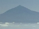
 Tenerife
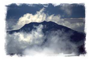
is dominated by Teide, Spain's
highest mountain, and the national park has some of the most dramatic mountain
scenery to be found in Spain, in the centre of the island high above the
clouds . Somehow, the humid cloudy coast without natural beaches has been
made popular as a holiday destination! (Note - don't think you will be
able to go off and find that deserted little cove on Tenerife, the few
that exist have long ago been discovered and are packed, and I mean packed,
with locals, naturists and hippies). The mountains are a much better bet
- Can be combined with La Gomera two
and a half hours away by car ferry (From 2000 ferry replaced by Gomera
Jetfast ferry [30 minutes] and flights from Tenerife to new frighteningly
small airport). Apart from Teide itself there are a good number of walks
in the Las Cañadas area, from easy to hard. Winter weather is usually
good for walking but storms, rain and snow are possible.
Tenerife
is dominated by Teide, Spain's
highest mountain, and the national park has some of the most dramatic mountain
scenery to be found in Spain, in the centre of the island high above the
clouds . Somehow, the humid cloudy coast without natural beaches has been
made popular as a holiday destination! (Note - don't think you will be
able to go off and find that deserted little cove on Tenerife, the few
that exist have long ago been discovered and are packed, and I mean packed,
with locals, naturists and hippies). The mountains are a much better bet
- Can be combined with La Gomera two
and a half hours away by car ferry (From 2000 ferry replaced by Gomera
Jetfast ferry [30 minutes] and flights from Tenerife to new frighteningly
small airport). Apart from Teide itself there are a good number of walks
in the Las Cañadas area, from easy to hard. Winter weather is usually
good for walking but storms, rain and snow are possible.
Photos
of Tenerife walks and drives
Climbing
Teide
Canarian
food
Discovery Walking
Guides :
Super durable
walkers maps 1:25,000 Ties in with 35 Tenerife walks![]()
Walkers map 1:25,000![]()
Walk! Tenerife
south guidebook![]()
35 Tenerife walks
guidebook![]()
Tenerife Indestructible
map: 1:100,000 island map + large scale street plans
+ large scale town plans and place name gazeteer, very useful as are all
Discovery maps ![]()
Plant and Flower
guide
Booklet
form in plastic wallet, cultivated and wild plants with photo and description![]()
Landscapes of
Tenerife![]()
Freytag &
Berndt Tenerife 1:75000![]()
AA Island map
Tenerife![]()
If you read Spanish" El Parque Nacional del Teide, Geo Planeta, Maximiniguias verdes" ISBN 412106-0is a good general & walking guide- Stanfords will order.
see
also:-
A
Birdwatchers Guide to the Canary Islands Clarke & Collins Bird Watchers
guides ISBN 1 871104 06 8
Histroia
Natural del las Canarias Guia Basica (spanish) Bramwell ISBN 84 7207
048 4
Tenerife
Blue Chaffinch
This
sometimes elusive bird can be easily seen at the "Mirador de la Cumbre"
above marker 26K on the TF24 road or at The Las
Lajas zona recreational at the south edge of the park.
Madeira is not strictly part of the Canaries, being Portugese, but is in the same geographical area. Some spectacular high level walks
June is known as the "dark month" when cloud covers most of the island.
 Discovery
Guides:-
Discovery
Guides:-
Discovery Tour
& Trail map (Super durable)![]()
Discovery 35
Madeira Walks avoiding the excessively underground or
vertiginous![]()
Discovery Drive!
Madeira![]()
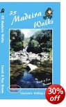
 Walking
in Madeira Cicerone
Walking
in Madeira Cicerone![]()
Landscapes of
Madeira![]()
![]()
Rother Walking
guide Madiera![]()
AA Island map
Madeira![]()