
Canary islands'
Flight simulator
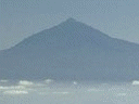
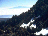
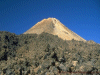
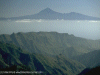
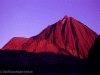
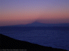
Teide - Spain's highest summit
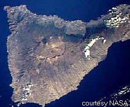 At 3717.91 metres (12198 ft)the volcano
Teide (Tay-dee) on the island of Tenerife
(Tenner-reef-ay) forms the highest peak on Spanish
territory and the worlds third largest volcano
(Last eruption 1909). The older extinct crater it
stands in can be seen as a rough circle at the
centre of Tenerife in the NASA image. Teide is the
cone at the north (top) edge of the rim. The two
calderas are designated as a national park and
access to the summit cone is strictly controlled.
Without a summit permit (free) walkers are only
allowed as far as the two miradors (viewpoints)
and their connecting path (shown in red on sketch
map) which contour the base of the final summit
cone at the top of the teleferico (cable car).
This restriction is essential because of the
potential erosion and disturbance that would be
caused by cablecar tourists going to the summit
(the National Park has 2.5m visitors a year). The
National Park are taking all precautions to
protect the natural environment of the park, for
example all the 4x4 tracks in the park are now
closed to non official traffic. There are also
rumours that the teleferico will be closed when
its operating license expires. Large numbers of
coach bourne tourists enter the park each day but
concentrate at the teleferico, Los Roques and a
patch of pleasant pumice convenient for coach
parking. Once 50 metres from these three sites you
will enjoy reasonable solitude.
At 3717.91 metres (12198 ft)the volcano
Teide (Tay-dee) on the island of Tenerife
(Tenner-reef-ay) forms the highest peak on Spanish
territory and the worlds third largest volcano
(Last eruption 1909). The older extinct crater it
stands in can be seen as a rough circle at the
centre of Tenerife in the NASA image. Teide is the
cone at the north (top) edge of the rim. The two
calderas are designated as a national park and
access to the summit cone is strictly controlled.
Without a summit permit (free) walkers are only
allowed as far as the two miradors (viewpoints)
and their connecting path (shown in red on sketch
map) which contour the base of the final summit
cone at the top of the teleferico (cable car).
This restriction is essential because of the
potential erosion and disturbance that would be
caused by cablecar tourists going to the summit
(the National Park has 2.5m visitors a year). The
National Park are taking all precautions to
protect the natural environment of the park, for
example all the 4x4 tracks in the park are now
closed to non official traffic. There are also
rumours that the teleferico will be closed when
its operating license expires. Large numbers of
coach bourne tourists enter the park each day but
concentrate at the teleferico, Los Roques and a
patch of pleasant pumice convenient for coach
parking. Once 50 metres from these three sites you
will enjoy reasonable solitude.
If staying at the Parador I suggest starting the Los Roques
For the ultimate night sky/sunrise
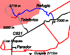 The Teide path is
shown in blue, other paths in red, roads in black
and the teleferico in grey. (Not to scale). About
ten cars can be parked at 'P' and overflow parking
is possible, if needed, a little to the west at a
mirador. The only accomodation and meals are
available at the Parador de Las Cañadas (pa-rar-door day
lass Can-yar-das)(4 star government owned mountain
lodge style hotel with seperate cafeteria, alt. 2200
metres) and accomodation only at the Refugio de
Altavista (alt. 3250 metres) - good for dawn at the
summit before permit system kicks in at 9am. Light
refreshments are available at the bottom station of
the teleferico. (Note that the teleferico does not
run in windy weather). No camping is allowed. There
are no shops or petrol (station marked on maps is
now closed and demolished) available in the national
park so any supplies should be purchased at the
coast (or Vilaflor) before tackling the unremitting
climb of one of the roads into the crater (2 hours
drive from airport to Parador - buses also run to
the park).The nearest town to the Park is Vilaflor
to the south (1466m) with shops, bars and
accomodation. The Las Lajas zona recreational at the
south edge of the park has camping and a restaurante
but is packed with barbecuing locals and coach
parties at the weekend. (This is incidentally a good
place to see the Tenerife
Blue Chaffinch) as are the trees around
Restaurante Bamba on the road fork at the east end
of the park)
The Teide path is
shown in blue, other paths in red, roads in black
and the teleferico in grey. (Not to scale). About
ten cars can be parked at 'P' and overflow parking
is possible, if needed, a little to the west at a
mirador. The only accomodation and meals are
available at the Parador de Las Cañadas (pa-rar-door day
lass Can-yar-das)(4 star government owned mountain
lodge style hotel with seperate cafeteria, alt. 2200
metres) and accomodation only at the Refugio de
Altavista (alt. 3250 metres) - good for dawn at the
summit before permit system kicks in at 9am. Light
refreshments are available at the bottom station of
the teleferico. (Note that the teleferico does not
run in windy weather). No camping is allowed. There
are no shops or petrol (station marked on maps is
now closed and demolished) available in the national
park so any supplies should be purchased at the
coast (or Vilaflor) before tackling the unremitting
climb of one of the roads into the crater (2 hours
drive from airport to Parador - buses also run to
the park).The nearest town to the Park is Vilaflor
to the south (1466m) with shops, bars and
accomodation. The Las Lajas zona recreational at the
south edge of the park has camping and a restaurante
but is packed with barbecuing locals and coach
parties at the weekend. (This is incidentally a good
place to see the Tenerife
Blue Chaffinch) as are the trees around
Restaurante Bamba on the road fork at the east end
of the park)Climbing Teide
Grade
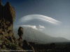
The path is well within the capacity of any British hillwalker without any scrambling being involved. It will be of interest to any walker who does not normally go this high, enjoys excellent views, or is interested in the novel experience, for the British walker, of climbing on a volcano. The only difficulties are lack of oxygen( 50% of sea level value at summit) and summer heat. Persons with a heart condition or who are pregnant should not attempt the climb. Long trousers, water, a fleece and lightweight waterproof jacket should be carried. In winter the usual additional equipment is required including glacier glasses to avoid snow blindness. (The angle of ascent is on average 7 and at maximum 12%).
Timing
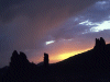
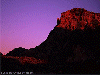
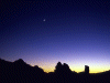
If climbing Teide in hot weather I recommend being on the hill before dawn, to avoid being caught by the sun low down on the mountain. This approach gives the bonus of watching the sun rise over the national park. (The start of the track is easy to follow by head torch.) Allow 5 hours (one way). Total ascent by this route is 1418 metres (4652 ft), not much more than Ben Nevis!
Temperatures
In the summer months this will be a hot walk, during the winter snow is likely, in February dawn temperature at the base of the mountain was -1C and 5C at the summit at noon.
Route
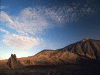
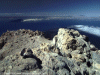
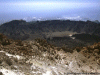
The path starts as a jeep track (closed to public) to the east of a prominent mirador. Signs and a large map mark the start. Keep to the track on an easy gradient, zig-zagging up past the "eggs of Teide" (large black rocks hurled from the volcano mouth) until signs indicate the start of the footpath which now leaves the pumice slopes and ascends the edge of a lava flow until being eventually forced onto the lava itself. Once on the lava you will be glad of the well engineered path across the uneven surface
When you have had enough of the views and retrace your steps to the teleferico, the guard will return your permit as a souvenier and you have the choice of walking back down or taking the cablecar (8 minutes - 20€ return) The cablecar is a good option if the day is becoming hot but bear in mind you must take care in returning to your car along the road. Do not become trapped between the retaining wall and passing vehicles.
On your return the Parador cafeteria has draught Dorada and a telescope on the terrace to admire your climb.
Obtaining your summit permit
Summit permits (free) are obtainable in person from :-
ICONA
Office P. N. de Teide,
Calle Emillio Calzadilla 5
38002 Santa Cruz de Tenerife
Phone 922 29 01 29 or 922 29 01 83
Opening hours (Monday to Friday except public holidays) 9 am to 2 pm
New 2011 - online booking - click here
You can now also obtain this permit by
fax or Email minimum 8 days in
advance. Fax 922244788
Email teide@oapn.mma.es
For further info phone 922290129![]()
Park in the underground carpark by the Plaza España (plarth-ah esp-an-ya)(an impressive pedestrianised square with the town hall on one side) on the seafront. Calle Emillio Calzadilla (ky-ay em-ey-e-oh kalth-ah-de-ah) runs at right angles to the coast road to the east of the Plaza España. The office is on the fourth floor of number 5 (press entryphone and enter). English usually spoken. If office has moved enquire at the town hall nearby.
You must present your passports here AND on the mountain.
You will also need a photocopy of the
"leaders" passport which is easier to obtain
before you arrive.
You will be allocated two days on
which to make an ascent (in August and February
the following two days were available) and must
specify a summit slot of two hours (allow 5
hours for climb). Only one ascent on one of the
two days may be made, but you may of course
abort an ascent at any time before the summit
checkpoint. Late/early arrivals at the summit
checkpoint will be treated sympathetically at
the discretion of the ranger. Maximum party size
10.
August 2003
The system has now become well known
(and therefore due for change?) and there was a
short queue at the office. The assumption was
made by staff that we intended to use the
telefericio and that if it was not running on
our day we could use our permit on the following
day.
A bit of
emergency Spanish (I doubt you will need it)
"Hola, Buenos dias. Por favor,
quisiera un permiso por la cumbre del Teide para
[uno, dos, tres] personas."
("Polite hello, please I would like a
permit for the summit of Teide for [one, two,
three ] people.")
oh-la bwen-oss de-as. paw fav-oor,
kee-see-air-a oon perm-esoh poor lah coombe-brey
del Tay-dee para [oon-oh, dos, tress]
per-son-as.
More on pronounciation
Walking in Canary Islands
Walking in Spain
Climate of Tenerife
Ann Bowker's Teide page
Walking in Tenerife
Volcano world-Tenerife