(approx. south to north order)
(click on thumbnails)


| La
Palma
(approx. south to north order) (click on thumbnails) |
|
|
Santa Cruz |
|
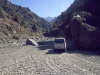
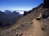
On the Camino Forestal that runs from Fuentecaliente to the metalled road above El Paso. |
|
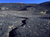
"Lunar" ash landscape above El Paso |
|
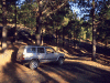
Inside the Caldera de Taburiente heading up the jeep track to Los Brecitos (the route is not up the Barranco as might appear from the photo, but merely crosses it here, the track ahead of our parked jeep is a maintenance track - note that 4 x 4 taxis are available for this route) |
|
Pico de la Sabina |
|
Pico de la Veta and the caldera crest path. |
|
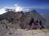
Pico de la Nieve and El Teide |
|
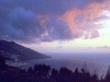
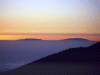
A typical cloud-sea forming a "cloudfall" above El Paso in the middle of the island. |
|
Morro de la Cresta near the observatory. |
|
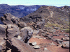
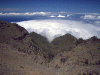
Typical path along the rim of the Caldera de Taburiente |
|
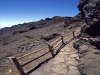
Some sections here and elsewhere are made up and fenced. |
|
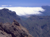
Typical cloud-sea view from the road to the observatory from Santa Cruz, 2000m above the sea. |
|
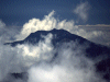
La Palma from Tenerife, the centre of the island submerged in cloud. |
|
Clouds off La Palma |
|
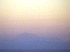
Tenerife from La Palma. |
![]()